The Australian and New Zealand Association of Antiquarian Booksellers Brighton Antique Prints and Maps
The French Connection
Brighton Antique Prints and Maps
Background
Strange how myths are perpetuated. Like the one that claims Captain James Cook discovered Australia. Or the myth that the English are responsible for the mapping of Australia. If we delve into the history of Australian cartography, we find that it is the French, not the English, who made the greatest contribution to the early mapping of our continent. In fact, given King Louis XVI and Napoleon’s interest in the great southern continent, it is surprising that we are not a nation of French speaking citizens.
Availability
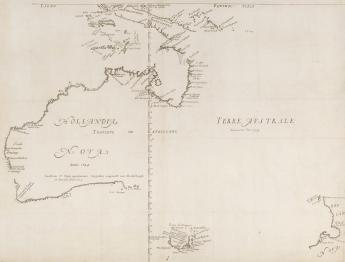
The first map of Australia is attributed to a Frenchman named Melchissedec Thevenot. Published in his work entitled “Relation de Divers Voyages Curieux” in 1663, it is also the first French map to record Tasman’s discoveries in both Australia and New Zealand. Most of Australia and the southern half of Tasmania are easily recognized on the map, however, the east coast of Australia is left blank. New Zealand is little more than a line drawn in the proximity of that country. There are six states (variations) of the map. The first state is exceptionally rare, whereas the third state appears on the world market once every three years.
The second earliest map of Australia appeared in Harris’ two volume work entitled “Navigantium Atque Itenerantium Bibliotbeca”. Published in 1744, it is a copy of the Thevenot map without any new geographic information. Plagiarism was rife, even in the eighteenth century. The serious collector should be able to locate a copy within two years.
The third earliest map of Australia is again by a Frenchman. His name is Jacques Nicolas Bellin, and his 1753 map appeared in Prevost’s “Histoire Generale des Voyages”. The map is significant, because it includes a hypothetical East coast of Australia, achieved by joining southern Tasmania, the New Hebrides and New Guinea. This map is offered a couple of times a year.
The French connection does not end here. A French scientific expedition led by La Perouse sailed into Botany Bay within days of the arrival of Governor Arthur Phillip and the first fleet. A Sydney suburb is named after him.
Finally, the simultaneous charting of Australia’s coast by Matthew Flinders and the French Baudin/Freycinet expedition is well documented. In fact, the two parties met at Encounter Bay just East of Adelaide in April 1802. Although Flinders was the first person to circumnavigate the continent, it is the French who have the distinction of publishing the first complete map of Australia. Freycinet’s map was published in Paris in 1811, three years before Flinders’ chart. It is not surprising that the French named features of the coast in honour of their Emperor. For example, Freycinet’s map identifies our Southeast coast as “Terre Napoleon”, the Gulf St Vincent as “Golfe Josephine” and Spencer Gulf as “Golfe Bonaparte”.
Price
The first state of Thevenot’s map was sold at the auction of Rodney Davidson’s collection for $60,000 plus buyer’s premium. The third state sells for $20,000 to $25,000 depending on condition. Priced at approximately $3,000, the Bellin map is relatively inexpensive for the collector who wishes to own one of the earliest maps of Australia.
Bibliography
For information about French maps of Australia, refer to “The Mapping of Australia [and Antarctica]” by R.V. Tooley and The Mapping of Terra Australis” by R. Clancy.
The article was first published in the “ANZAAB Aspects of Book Collecting” on www.anzaab.com, and is presented here, with our thanks, by permission of the ANZAAB.