Tip Antiquarian Booksellers' Association of America
Collecting Rare Books and First Editions - Why I Bothered
By Greg Gibson
Insurance has been around for a long time.
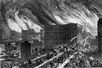
Back in the 19th century, as American cities began to proliferate, wood was still the primary building material, but construction standards were virtually non-existent. Catastrophic fires – Chicago comes to mind – were an ever present threat.
Commerce, and the financial infrastructure that supported it, was undergoing explosive growth, and insurance became a necessity. But one standard for insuring a building in a city did not fit all buildings. In order to assess potential liabilities insurers needed to know, building by building, what the potential fire risk was.
Fire insurance mapping began in London in the 1700s, but it had never been applied with a systematic approach. In 1867 Daniel Alfred Sanborn, a surveyor from Massachusetts, saw the need for such a service, and quickly occupied that niche. By the late 1800s he had offices spanning the continent, sending out thousands of surveyors to record the footprints and construction details of buildings in American cities. Insurance companies could then use this information to write accurate policies, based on potential fire risk as documented by Sanborn’s company.
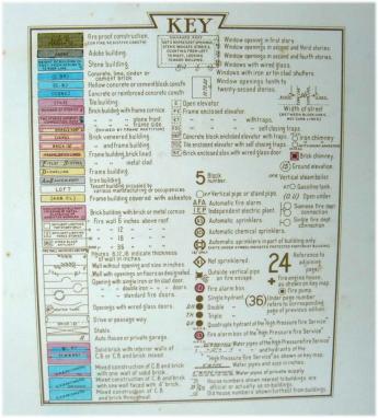
This information was presented in large folio atlases, each page a colored lithograph map of a relatively small area depicted at 1:600 or, less commonly, 1:100 scale. Every structure within that area was color coded, and bore an elaborate but efficient annotation of text and symbols that allowed a potential insurer to gauge its risk of fire.
Ultimately, the structures of more than 12,000 towns and cities were documented in exquisite detail.
Back in my days as a retail used book dealer, Sanborn atlases turned up with some frequency. They were esteemed by historical societies and hardcore local history buffs, but they weren’t as laden with nostalgic information as older atlases and were, generally speaking, a tough sell – even in the low hundreds of dollars. Apparently, that hasn’t changed much for the smaller towns, although multi-volume Sanborn atlases for big cities are now bringing big dollars.
Flash forward to last week’s rather marginal New Hampshire Book & Ephemera fair, and the question – always on my mind – of why I bothered to spend a weekend there, having sold only $200 worth of books.
Well, yes, I had some entertaining and instructive conversations, and bought some interesting stuff. But on Sunday afternoon a colleague, having seen my rare three volume set of Eldred harbor charts covering the coast from New York to Bar Harbor, told me he had a pair of atlases – not by Eldred, he wasn’t exactly sure what they were – that covered similar territory. Would I be interested? Yes, I’d be interested in taking a look.
Five days later, as we were having dinner Jim, our UPS man, shouted through the office door into our kitchen in his usual good humored manner, that he had just delivered a 51 pound package. Perhaps my children or guests would be interested in helping me convey it from my office threshold to – wherever. Anyway, he was happy to inform us that it was off his truck.
In the pearly light of the next morning, after the considerable labor of schlepping it to the packing table and undoing its elaborate packaging, Jim’s delivery turned out to be the item promised by my colleague at the New Hampshire book fair - a Sanford atlas unlike any I’d seen before.
The item is described below, but here I’d like to interject the two timeless truths of which its receipt has once again reminded me.
1. Why was I doing that lame-ass book fair for the thousandth time?
Because you’re not going to get the book unless you go where books are. You’ve got to show up for work, however you might define “work.”
2. I thought I knew everything about Sanborn atlases, But if you keep an open mind in this business, you learn something new every day.
Sanborn Map. Co. WATERFRONT PROPERTIES. FIRST NAVAL DISTRICT. VOLUME ONE. (AND) VOLUME TWO. Pelham, NY n.d. (ca. 1916). Color lithographed maps. Folio. Sheet size 22 x 25 1/4 inches. 254 full page maps plus index maps. Sanborn maps were used by insurance companies to assess the risk of fire. They are highly detailed, showing each structure in a specific area. Text, color, and other symbols give construction material, type of construction, use, owner, number and location of doors and windows, utilities, streets, natural features, and much more information. A key to this complicated but efficient system of coding is presented on the title page of each volume. These atlases were very useful in their day, and now are rich sources of historical information. Taken together they constitute an unrivaled source of documentation of the urbanization of this country, as well as a “snapshot” of businesses and residences in each location at a given time. It is estimated that there are Sanborn atlases for over 12,000 towns and cities in the U.S. They occur with some frequency in the trade. Sanborn atlas groups for major cities such as New York or Los Angeles bring five-figure prices. These two atlases, however, are extraordinary. They depict, in great detail - the rarely used 1:100 scale - the working waterfront of the northeast - from Southwest Harbor, Maine to Boston, Massachusetts. Volume One contains 153 full page maps, plus index maps for each region. Waterfronts depicted include Bath, Portland, Portsmouth, Gloucester, Salem, New Bedford, Newport, and Provincetown. Many cities are shown in multiple maps - Providence, for example, has twelve maps documenting its waterfront. Volume Two contains 101 maps plus index maps, and covers Boston, Breed’s Island, Charlestown, Chelsea, Dorchester, East Boston, Everett, and South Boston. Both are bound in durable cloth covered boards with leather labels. Maps are clean and bright, some marginal spots of acid burn from old leather index labels. An unparalleled snapshot of New England’s waterfront in the early 20th century. Two vols. $2500
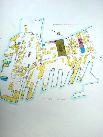
As an afterthought about the utility of this atlas, here’s a detail of the “Fort” neighborhood in Gloucester.
A close look at the actual map shows this part of town to have been a vibrant mix of maritime, manufacturing, retail and residential uses – including Clarence Birdseye’s first frozen foods plant. Now Jim Davis, the very successful founder of New Balance shoes, is now proposing to put a hotel there.
Make of that what you will…
(Posted in Bookman's Log. Presented here by permission of the author.)