Tip Verband Deutscher Antiquare e.V.
Collecting Rare Books and Ephemera - The GPS of the 1960s

By Frank Werner
It is not always the very expensive or very old book that takes the fancy of the antiquarian bookseller. Quite often it is the unusual, the strange, or the odd that delights and entertains him.
Before practically everyone had one of these cunning little electronic navigation systems, there used to be road atlases. These were usually published by automobile clubs. They were heavy and cumbersome and one had to flip from pp. 14/15 to 168/169 at a moment’s notice, most often when you had just missed junction 5 or 6 or 7 on a major highway. The place you were looking for in the road atlas was usually right in the fold, and navigating with it taxed the driver’s and his navigator’s patience to the utmost. If you drove alone it was even worse.
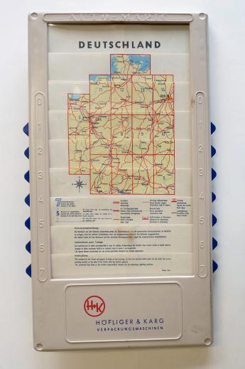
However, someone recognized the problem and came up with this amazing little gadget:
Auto-Mapic – Automobile map of Germany. Vienna ca. 1960. In a light plastic frame
This is an interesting attempt at reducing the size of a road atlas. The 15 maps are arranged like slats in a frame. By moving short handles protruding from the sides of the frame, one map can be pushed over the other. Perhaps this arrangement was somewhat tricky, very few copies seem to have survived. Mine works perfectly, however! I have tested it, and I had less problems with it than with my new GPS.
This entertaining little object is of interest for the student of the byways of cartography as well as the collector of all things car-related. You can find it in my latest “Catalogue CCIX”, which will be appearing shortly.
This collecting tip is published in the new blog “Books and other Animals” by Frank Werner of Brockhaus / Antiquarium where, within the upcoming weeks, you will find everything absurd and fascinating on travel and travel books.
